Pages

Saturday, July 9, 2011

Overview of the List

There are more than 7,100 islands in the Philippine Archipelago, all of which hold unending pristine wonders which make it a superb summer camp of tourists. Aside from the beaches and the tropical climate, Mother Nature has since favored this archipelago and has continuously made it a paradise.
Here is the list of seven natural wonders carved and molded by Mother Nature. Get to know each one and let this presentation make you dream to experience a 7,100 times more exciting and more adventurous – and perfectly wonderful tour.

Mayon Volcano


Called the ‘Perfect Cone’ by the locals, the Mayon Volcano is an icon of Philippine Tourism. Almost all Filipinos think of Mayon as beautiful, yet dangerous.

What is the Mayon Volcano?
Mayon Volcano is a stratovolcano (conical volcano) rising 2,462 meters above sea level. It is one of the most active volcanoes, having erupted about 50 times over four centuries, the most notable of which was the 1814 eruption which buried towns. The said eruption left the Cagsawa Belfry Tower in ruins, the figure of it now being a part of the typical Mayon Volcano posters.

Where can we find the Mayon Volcano?
The volcano is in the eastern part of the Philippines, in the Bicol Region. It is a part of the Pacific Ring of Fire which faces the Pacific Ocean.
The known jurisdiction of the volcano goes to Daraga, Albay.

How did mother nature mold this wonder?
Along the eastern part of the country is a part of the so-called Pacific Ring of Fire. Magma and other hot materials inside earth found way to over the ground. The openings in the ground rose significantly because of the rising rock layers forced by water trapped by minerals and rocks. Mayon Volcano is known as the most active volcano in the Philippines. Its continuous eruptions formed the perfect cone. The rugged side of the mountains are layers of lava and other volcanic materials.

Mount Apo Natural Park

The highest part of the country is a dormant volcano deemed as the ‘grandfather of all mountain’. The term is translated in the local language as ‘apo’, hence Mount Apo.
Mount Apo is flat-topped mountain. It occupies an extensive area at its base, which became one of the most diverse ecological system in the country. The area boasts of different kinds of forests – from tropical rainforest at the base, to the midmountain forest, to the high mountain forests. Each category boasts of its rich biodiversity.
The park is one of the most popular climbing area of adventurers. Along the trails leading to the summit are waterfalls, streams, springs, and a variety of fauna and flora only found in the area.

What is the Mount Apo Natural Park?
There are basically two reasons why the park is important in the natural scene of the country. First, the highest mountain in the country rises at the middle of the park’s extensive forests, complete with natural springs, falls, streams and rivers. Second, the great concentration of animal and plant life find home in the mountain’s base. The highest peak (there are three peaks) is 2,954 meters above sea leve.
The park is home to the renown Philippine Eagle, the second largest eagle in the world. Along with the eagle are more than a hundred birds found only in the park and nowhere else in the world. The forests are also in the limelight for having wild endemic flowers like ‘waling waling’ (considered Queen of Orchids), and varieties of rafflesia (the largest flower in the world). It is also a home to the king of fruits called ‘durian’.
The area covers about 55,000 hectares. The highest point (the peak) is a part of Davao City.

Where can we find the Mount Apo Natural Park?
The park is between the city of Davao, and the province of Davao del Sur. It is located in Mindanao, south of the archipelago.

How did mother nature mold this wonder?
The forests are formed mainly because of the rich soil which was a result of the ancient eruptions of Mount Apo. The area became forested and various animals found home in them. Species of plants were able to adapt in the area though the years.
Mount Apo’s formation is due to its volcanic activity and due to the presence of various faults in the country.

Tubbataha Reef

In an area in the middle of the ocean are small islands surrounded by colorful corals, which are breeding grounds for a lot of fishes, whales, sharks, turtles, and birds.
The Tubbataha Reef is far-famed internationally but otherwise locally unpopular. It is only a manifestation that this wonder is untouched and less explored, which is a good thing because exploitation always corrupts nature.
The Reefs are perfect example of the work of nature. It is a site for adventurous divers, and others who want to explore the beauty of the community made by marine living organisms.
It is also a UNESCO World Heritage Site, actually it is the first natural park in the Philippines included in the list.

What is the Tubbataha Reef?
The Tubbataha Reef is the general name of the area comprising two atolls (the North Atoll and the South Atoll), and a cay named Jessie Beazley Reef. The area is extensively named The Tubbataha National Park, or Tubbataha in short.
It is an atoll reef (meaning it is a circular island with a lagoon in the center) system which is home to a lot of marine species like dolphins, sharks, fish, turtles, and many others. The islands are also summer and winter homes to many migratory birds (some took refuge to this island for throughout the year).
The coral reefs in the park are considered the richest in the Philippines, of which 90% of all kinds of corals in the country could be found here.
The park covers an area of 130,000 hectares and reaches down to about 750 meters deep in the middle of the three atolls (the deep sides are open seas). The reefs themselves reach down up to 100 meter of corals.

Where can we find the Tubbataha Reef?
The Tubbataha Reef is in the middle of Sulu Sea (an area between Palawan and Mindanao Islands) in the Midwestern part of the Philippines. It is legally a part of the Palawan Province, southwest of Puerto Princesa, its capital.
The park is located in the multinational area called the Coral Triangle, which extends from the West Philippine Sea to the Pacific Ocean, covering much of the Philippines, Indonesia and Papua New Guinea.

How did mother nature mold this wonder?
Philippines being an archipelago is rich in marine life, which are brought by its warm waters. The Tubbataha Reef is a perfect example. Unlike other reefs, the atoll is circumferential.
Millions of years ago, a volcano (or volcanoes) was formed under the ocean. Marine life, like corals surrounded the volcano which became extinct. As the sea subsided, the corals formed an island around the volcanic island, which then started subsiding. The island became a lagoon and the surrounding corals became what is now the reef.
The Tubbataha Reef is a perfect example of an atoll, made more perfect by the continuous building of the rich biodiversity of the region.

Hundred Islands

Filipinos know that when high tide, the total number of islands in the Philippines is less than one. That island being submerged by the tide is a part of the beautiful chain of islands in what is called the Hundred Islands National Park.
The Hundred Islands are ideal for their white-sand beaches and other natural features in the marine and inland parts. This is probably the best place for the term island-hopping due to its more than a hundred varied-size islands and islets, majority of which are not yet commercialized and as locals say ‘virgin’.
The waters in the park is perfectly calm and tropical, which is ideal to many activities.


What is the Hundred Islands National Park?
This is a natural park composed mainly of the 124 islands (less one if high tide) scattered in the Lingayen Gulf in Pangasinan. The park features the islands with their white-sand beaches and forested inlands, which includes among others eroded karst and lushes. The islands are scattered in less than 20 square kilometers.
Between these islands are the clear waterways ideal for swimming, diving, snorkeling. The town Anda is said to be the largest among the islands, and is often called its ‘mother island’. Only three among the hundred islands are commercially developed and are mostly accessible to tourist. Others are open to activities like swimming, boating, parachuting, jetskiing, jetlevs, and other forms of island-hopping.

Where can we find the Hundred Islands National Park?
The park is located in the Alaminos town of Pangasinan Province in the Ilocos Region. The province is north of Manila.
The islands are scattered in the Gulf of Lingayen, which is an arm of the open seas called the West Philippine Sea.

How did mother nature mold this wonder?
About two million years ago, the western shore of this region was a part of the open seas. The sea was rich in coral reef and other marine creatures. When the sea became low, the fully developed corals became solidified and became islands, hence the ‘mushroom-like’ appearance.

Puerto Princesa Underground River

When streams of waters create waterways, rivers are formed. But it is a wonder of nature when the water passes through a cave and drains itself to the sea.
The Puerto Princesa Underground River is a subterranean waterway under a mountain range. It is one of the longest rivers flowing under the earth.
What makes it more beautiful is the system of navigable caves which boast of karst formation and internal natural stalagmite, stalactite, and columns.
The river is a part of the larger Puerto Princesa Underground River Natural Park, which is included in the list of UNESCO World Heritage Sites.
Also, it won a spot in the global poll for the Seven Wonders of Nature. It is included in the list because of the uniqueness of its formation and because of its rich mountain-to-sea ecosystem.
The coastal part (St. Paul Bay) features mangroves, grassy sea bed, and coral reefs.


What is the the Puerto Princesa Underground RIver?
Underground River is a unique formation of nature. The PPUR is the longest navigable subterranean river, and second longest of its kind (the longest is in Mexico).
It is named Puerto Princesa Underground River after the city of Puerto Princesa, which has its jurisdiction. The river (locally known as the Cabayugan River) passes through the mountain range called St. Paul Mountain Ranges. The journey of the water is composed of 8.2 kilometers from river tributaries into the West Philippine Sea (earlier name: South China Sea).

Where can we find the Chocolate Hills?
PPUR is in the northwest of Puerto Princesa City, the capital of Palawan. Palawan is an archipelago-province in the western Philippines.

How did mother nature mold this wonder?
The Cabayugan River and its tributaries formed their waterways through the cavities of the mountains in the St. Paul Mountain Range. The river is sloped about a hundred meter and rapidly made ways to pass into the systems of caves. It found its way to the St. Paul Bay which is directly a part of the West Philippine Sea.

Taal Lake


It is proudly known to local tourists as a ‘lake within an island within a lake within an island, This is because it is indeed a lake within an island-volcano, which lies on a lake, enclosed in an island.
This wonder of nature is a jewel of blue waters and the dangerous gift of one of the most active volcanoes in the world.


What is the Taal Lake?
Taal Lake is the third largest lake in the Philippines. It is far-famed for having a compound of volcanoes which are collectively known as the Taal Volcano. The Taal Lake is not the island in the mouth of the volcano, the fact that most tourists know.  The Crater Lake is also called Taal Lake and is generally accepted as a part of the large lake.
The lake is on the island of Luzon. It is a rich lake in terms of biodiversity. Its sulfuric freshwater is home to several endemic and adapted fauna.

Where can we find the Taal Lake?
The Taal Lake is two hours off Manila. It is a part of the province of Batangas, but there are magnificent viewpoints and resorts in the City of Tagaytay which is a part of the province of Cavite.

How did mother nature mold this wonder?
Taal Volcano was once a seawater part of the Balayan Bay of Batangas. Since it was a little too inland, it was easy to be enclosed and become landlocked, especially because of the activity of the island volcano near its center. Actually, most towns in its shore were buried in past eruptions.
The lake was formed and became freshwater, but with sulfuric content because of the presence of the volcano. The volcano itself is a wonderful work of nature. It rose from the bottom of the sea by continued flow of lava over the long period of time. The crater lake, which is much majestic and mystical in view was formed from its larger eruption and more massive lava flow.

Chocolate Hills

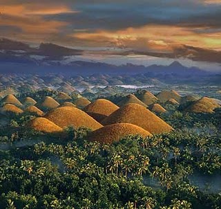
The Chocolate Hills

 
This geological formation is known to almost every Filipino. In fact, the representation of a ‘hill’ to the Filipinos is a cone-shaped brown mound referenced to those of the Chocolate Hills.
This site is one of the pillars of Philippine Tourism and one of the few natural wonders which do not feature water. As we know, water (beaches, rivers, falls) are always in the front of the Philippine Archipelago Tourism.
The uniqueness of these landforms led to the declaration of it as a national monument.

What are the ‘Chocolate Hills’?
The Chocolate Hills are karst formation which dates back in the Pleistocene Era. Almost all of the hills are cone-shaped. There are a total of 1,776 hills which are concentrated on three landlocked towns of the island. However, there are also a number of these hills in other three towns. The hills are 30-50 meters high and amazingly there is no single tree on them.
These cone-shaped hills are covered in green, but during the dry seasons these grasses die and leave the hills in broad sunlight. The exposure to sunlight to the soil make it appear brown.  Hence, the name.

Where can we find the Chocolate Hills?
The Chocolate Hills are found in the beautiful island of Bohol. The island-province is situated in the Central Philippines, few kilometers off the island province of Cebu.

How did mother nature mold this wonder?
Long before men inhabit earth, there were still no hills in this area. Instead, corals and other marine creatures lived. There was no Bohol then, the area was still totally submerged in water. The waters became shallow and the remains of the corals became limestone which eroded and became what is now known as the ‘Chocolate Hills’.